Search Term Record
Metadata
Name |
steel groin |
Number of Archive records |
0 |
Number of Library records |
0 |
Number of Object records |
0 |
Number of Photo records |
75 |
Related Records
-
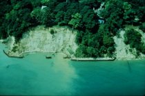
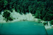
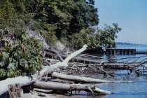
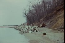
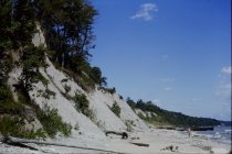
Aerial view of Bunting Bluffs - aerial view of Bunting Bluffs (south of south beach) looking west showing severely eroded bluffs - mostly likely circa 1983 due to high lake levels and Bunting Bluffs have been filled with debris and revegetated
Aerial view of Bunting Bluffs
Record Type: Photo
-
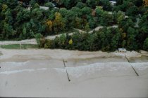
Aerial view of Central Beach - aerial view of central beach looking west - time period between 1976 and 1983 - note Lake Bluff Open Lands Association planting area not yet installed at bottom of new beach road - high water period on lake note rubble in front of beach house
Aerial view of Central Beach
Record Type: Photo
-
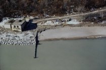
Aerial view of Central Beach and beach house - aerial view of north end of Central Beach looking westerly showing rubble placed around beach house high water levels on beach - Companion with Slide #'s 905 and 906
Aerial view of Central Beach and beach house
Record Type: Photo
-
Aerial view of Lookout Point and Bunting property - aerial view looking westerly at severely eroded bluffs of historic Bunting parcel (aka Nyquist, Lookout Point ) and south end of south beach bluffs - shows deteriorated steel groins - This photo is adjacent to Slide #899 - August 1974 Date provided by ILL Geologic Survey
Aerial view of Lookout Point and Bunting property
Record Type: Photo
-
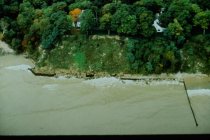
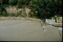
Aerial view of NSSD parcel and Central Beach - aerial view of north end of North Shore Sanitary District (NSSD) parcel and south end of central beach - shows newly installed stone revetment in front of North Shore Sanitary District (NSSD) - shows Lake Bluff Open Lands Association planting area in place at bottom of new beach road- Companion with Slide #'s 904 and 905
Aerial view of NSSD parcel and Central Beach
Record Type: Photo
-
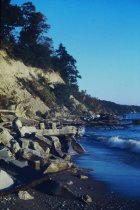
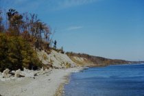
Aerial view of South Beach bluffs - aerial view of south beach bluffs and beach looking westerly - high lake level - beach installed in 1975 at south end of south beach has been eroded away - companion with aerial slide #900
Aerial view of South Beach bluffs
Record Type: Photo
-
Aerial view of South Beach bluffs and NSSD area - aerial view of south beach bluffs looking westerly showing severely eroded bluff - most likely circa 1983 due to high lake levels - no later than 1985 - shows Yacht Club facilities and North Shore Sanitary District (NSSD) with old building south of Pumping Station
Aerial view of South Beach bluffs and NSSD area
Record Type: Photo
-
Aerial view of South Beacs and Yacht Club - aerial view looking westerly at severely eroded South Beach bluffs, shows concrete rubble on bluff at south end - shows Yacht Club facilities at north end and original North Shore Sanitary District (NSSD) building at far right edge - no shore protection at Yacht Club - Reference Slide #526
Aerial view of South Beach Bluffs and Yacht Club
Record Type: Photo
-
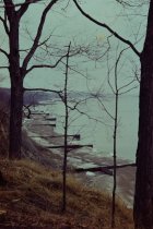
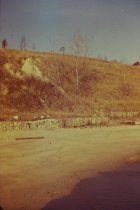
Beginning of slide at Mountain Bluffs - view northwest from 1939 long concrete pier showing start of Mountain Road bluff failure, 1949 short steel groin which is adjacent to short 1939 concrete pier(not shown) - in far right is debris on slope at south end of Bluff Road property
Beginning of slide at Mountain Bluffs
Record Type: Photo
-
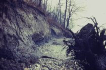
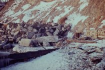
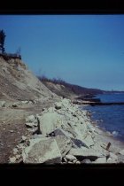
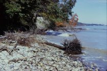
Debris at base of Dalitsch Bluff - view looking north along beach from north end of North Beach showing eroded Dalitsch bluff - concrete debris in foreground is at base of Mountain Avenue bluff - 1949 short steel groin visible and debris at base of Dalitsch bluff
Debris at base of Dalitsch Bluff
Record Type: Photo
-
Erosion at Bluff Road bluff - view looking north along beach from end of Lillian Dells Drive showing debris on Bluff Road Bluff and continuing erosion, Crab Tree Farm steel groins in background
Erosion on Bluff Road bluff
Record Type: Photo
-
Erosion at Bluff Road bluffs - view looking north northwest from end of long concrete pier showing short concrete pier and adjacent steel groin, also shows very eroded Bluff Road bluffs, debris at base of Dalitsch property, partially eroded Crab Tree Farm bluff in distance with steel groins at Crab Tree Farm
Erosion at Bluff Road bluffs
Record Type: Photo
-
Erosion at Bluff Road Bluffs - view northwest from end of 1939 concrete pier (telephoto view) showing 1939 short concrete pier with adjacent steel groin, rubble at base of Dalitsch property, and eroded Bluff Road bluffs with armor stone and concrete debris at base of bluffs
Erosion at Bluff Road bluffs
Record Type: Photo
-
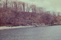
Erosion at Crabtree Farm bluffs - view looking north along beach from Lillian Dells Drive, showing eroded Bluff Road bluffs and eroded Crab Tree Farm bluffs in the distance - end of winter scene showing ice and snow buildup on beach, southerly Crab Tree Farm steel groin in distance
Erosion at Crabtree Farm bluffs
Record Type: Photo
-
Erosion at Crab Tree Farm bluffs - view looking north from 1939 short concrete pier showing extensive erosion of Bluff Road bluffs, large rubble revetment along base of Bluff Road Bluff, steel groin at south end of Crab Tree Farm, rubble along base of Dalitsch bluff and Dalitsch steel revetment in left foreground
Erosion at Crab Tree Farm bluffs
Record Type: Photo
-
Erosion at Mountain Avenue bluff - view looking north along base of Mountain Avenue bluff taken from just north of long concrete pier - shows start of erosion of bluff in this area - in background is 1949 short steel groin installed immediately south of the 1939 short concrete pier
Erosion at Mountain Avenue bluff
Record Type: Photo
-
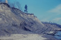
Erosion at Mountain Bluff - view looking north from north end of north beach showing closeup view of erosion of Mountain Avenue bluff
Erosion at Mountain Bluff
Record Type: Photo
-
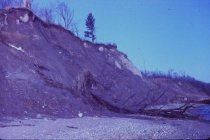
Erosion at Mountain Bluffs - view looking northwest taken from lake of severely eroded Mountain Avenue and Dalitsch bluffs, short steel groin near where 1939 short concrete pier use to be located is shown in lower right foreground late 1970s to 1980s
Erosion at Mountain Bluffs
Record Type: Photo
-
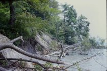
Fallen trees at base of Mountain Bluffs - view north along beach showing closeup view of 1949 short steel groin adjacent to 1939 short concrete pier (not shown) - shows erosion along shoreline with much new tree fall at base of Mountain Ave
Fallen trees at base of Mountain Bluffs
Record Type: Photo
-
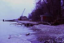
Installation of 1973 steel groin - view south southeast from north end of central beach - shows installation underway of 1973 steel groin in middle of central beach
Installation of 1973 steel groin
Record Type: Photo
-
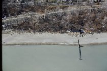
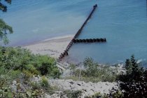
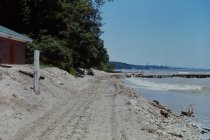
Looking down old beach road - view down old beach road taken from midpoint on beach road - shows 1975 steel groin in place at north end of north beach
Looking down old beach road
Record Type: Photo
-
Looking down the Bluff Road bluffs - view looking easterly down bluff taken from north end of Hall property (north end of Bluff Road properties and just south of south end of Crab Tree Farm parcels - shows newly dumped concrete debris on bluff - steel groin is the southerly groin on the Crab Tree Farm parcel
Looking down the Bluff Road bluffs
Record Type: Photo
-
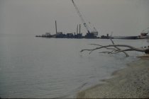
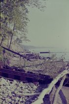
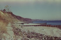
Looking south towards pump station - view looking south from north beach, shows extensive beach erosion, beach house, 1973 steel groin in middle of central beach - half completed, North Shore Sanitary District (NSSD) and outfall pipe in rear - crane in rear most likely installing shore end
Looking south towards pump station
Record Type: Photo
-
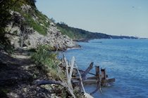
Looking up Crab Tree Farm bluffs - view looking west north west up south end of Crab Tree Farm bluff - photo taken from lakefront - photo shows eroded bluff and gabion baskets installed along toe of bluffs
Looking up Crab Tree Farm bluffs
Record Type: Photo
-
Looking up the Bluff Road bluffs - view looking northwest up Bluff Road bluff taken from beach at end of Lillian Dells Drive - shows eroded Bluff Road bluffs with Stearns' Chimney and chain link fence on top of bluff at south end of Crab Tree Farm - steel groin is at south end of Crab Tree Farm opposite East Blodgett Avenue
Looking up the Bluff Road bluffs
Record Type: Photo
-
Looking up the Bluff Road bluffs - view looking northwest up Bluff Road bluff taken from beach at end of Lillian Dells Drive - shows eroded Bluff Road bluffs with Stearns' Chimney and chain link fence on top of bluff at south end of Crab Tree Farm - steel groin is at south end of Crab Tree opposite East Blodgett Avenue
Looking up the Bluff Road bluffs
Record Type: Photo
-
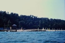
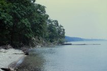
Looking west towards bluffs - view looking northwesterly at Lake Bluff central beach and northerly portion of North Shore Sanitary District (NSSD) parcel - photo taken from a boat - view shows North Shore Sanitary District (NSSD) southerly steel groin on left and two outfall pipes; Yacht Club compound and Old North Shore Sanitary District (NSSD) plant in back - also boats on beach
Looking west towards bluffs
Record Type: Photo
-
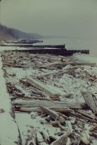
Remnants of long concrete pier on north beach - view looking south along beach taken from north end of beach - remnants of 1939 long concrete pier are along toe of bluff, pier removed spring of 1975 - eroded south end of Mountain Ave bluff shown, 1975 steel groin at north end of north beach is in foreground, beach house
Remnants of long concrete pier on central beach
Record Type: Photo
-
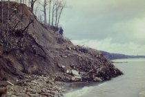
Rubble at base of Bluff Road bluffs - view looking southwesterly at north end of Bluff Road bluff taken from just north of southerly Crab Tree Farm steel groin - shown in right foreground is the southerly end of short rock / wall gabion baskets constructed along southerly portion of Crab Tree Farm bluff
Rubble at base of Bluff Road bluffs
Record Type: Photo
-
Rubble at base of Bluff Road bluffs - view looking southwesterly at north end of Bluff Road bluff taken from most southerly steel groin of Crab Tree Farm - view shows ruble and rocks spread along toe of north end of Bluff Road bluff
Rubble at base of Bluff Road bluffs
Record Type: Photo
-
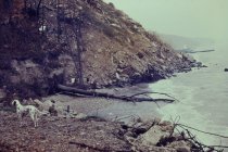
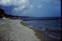
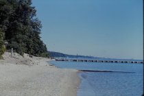
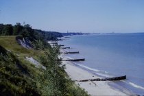
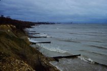
View north along the beach - view along lakefront looking north along Crab Tree Farm groin field - picture taken near south end of Crab Tree Farm property - note gabion baskets on left side of photo
View north along the beach
Record Type: Photo
-
View north along the beach - view looking north along base of Mountain Avenue bluff taken from west end of concrete pier - shows start of erosion Mountain Avenue bluff - eroded narrow beach and in background is 1949 short steel groin installed immediately south of the 1939 short concrete pier
View north along the beach
Record Type: Photo
-
View north along the beach - view looking north along beach from approximately 1939 short concrete pier - shows concrete debris along base of Dalitsch bluff with concrete bracing of Dalitsch steel revetment just beyond - eroded Bluff Road bluff in center and Crab Tree Farm bluffs beyond - southerly Crab Tree Farm groin shown beyond
View north along the beach
Record Type: Photo
-
View north along the beach - view looking north along beach from Dalitsch parcel showing huge debris pile on south end of Bluff Road bluff, Dalitsch steel revetment in foreground with support structures, and Crab Tree Farm steel groins in background
View north along the beach
Record Type: Photo
-
View north along the beach - view looking north along beach from immediately south of Lillian Dells Drive showing south end of Bluff Road bluffs with extensive debris on Bluff Road bluff, Crab Tree Farm steel groins in background and concrete debris at northeast corner of Dalitsch property in the foreground
View north along the beach
Record Type: Photo
-
View north along the beach - view looking north along beach of eroded Mountain Avenue and Dalitsch bluffs taken immediately south of 1975 steel groin installed at north end of North beach - shows concrete debris at base of Mountain bluff and at base of Dalitsch bluff - also 1949 short steel groin
View north along the beach
Record Type: Photo
-
View north along the beach - view looking north along beach opposite Bluff Road bluff - shows beach area along Bluff Road Bluff in foreground one year after rock revetment constructed at toe of bluffs - Crab Tree Farm groins in background
View north along the beach
Record Type: Photo
-
View north along the beach - view looking north along beach taken from approximately 1939 short concrete pier - shows concrete bracing for Dalitsch steel revetment on left foreground - eroded Bluff Road bluffs in center and eroded Crab Tree Farm bluffs in background - southerly Crab Tree steel groin in background
View north along the beach
Record Type: Photo
-
View north along the beach - view looking north along beach taken from approximately shore end of 1939 long concrete pier - shows eroded Mountain Avenue and Dalitsch bluffs and concrete debris on bluff - also shows 1949 steel groin adjacent to short 1939 concrete pier
View north along the beach
Record Type: Photo
-
View north along the beach - view looking north along beach taken from Lillian Dells Drive - shows eroded Bluff Road bluffs and Crab Tree Farm bluffs in distance - steel groin shown is the southerly most groin at Crab Tree Farm aligned with E. Blodgett Avenue extended
View north along the beach
Record Type: Photo
-
View north along the beach - view looking north along beach taken from middle of Bluff Road bluffs, showing eroded Bluff Road bluffs and shows rock revetment work underway - nearest steel groin shown is at the south end of Crab Tree Farm opposite East Blodgett Avenue, eroded Crab Tree Farm bluffs in background
View north along the beach
Record Type: Photo
-
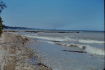
View north along the beach - view looking north along central and north beach and beyond - shows sign posted at the steel groin at the north end of central beach (due east of beach house) which reads "No Swimmers On This Beach" due to severe Mountain Avenue Bluff Erosion
View north along the beach
Record Type: Photo
-
View north along the beach - view looking north along central and north beach from south end of central beach - shows narrow beach, partial view of beach house, construction road along beach, 1949 central beach short steel groin in foreground and long concrete pier in background
View north along the beach
Record Type: Photo
-
View north along the beach - view looking north along Crab Tree Farm lakefront - view taken at base of bluffs next to gabion basket wall installed along toe of bluff - view shows steel groin field along Crab Tree Farm lakefront
View north along the beach
Record Type: Photo
-
View north along the beach - view looking north along Mountain Avenue bluff and north end of North Beach bluff taken from shore end of 1939 long concrete pier - close up view of erosion at base of bluff - 1939 short concrete pier with 1949 steel groin in distance
View north along the beach
Record Type: Photo
-
View north along the beach - view looking north along north end of central beach and north beach - shows beach being used as construction road for North Shore Sanitary District (NSSD) pump station - very narrow beach adjacent to the beach house - long concrete pier is shown and short steel groin next to short concrete pier in background
View north along the beach
Record Type: Photo
-
View north along the beach - view looking north along north end of central beach and north beach - shows beach being used as construction road for North Shore Sanitary District (NSSD) pump station - very narrow beach, long concrete pier in d background and 1949 short steel groin in foreground
View north along the beach
Record Type: Photo
-
View north along the beach - view looking north along Southerly end of Crab Tree Farm lakefront - photo taken from top of Bluff from middle of Bluff Road properties - photo shows eroded Crab Tree Farm bluff and steel groin field installed along south end of Crab Tree Farm - southerly groins aligns with East Blodgett Avenue
View north along the beach
Record Type: Photo
-
View north along the beach - view looking north along Southerly end of Crab Tree Farm lakefront - photo taken from top of Bluff from middle of Bluff Road properties - photo shows eroded Crab Tree Farm bluff and steel groin field installed along south end of Crab Tree Farm -southerly groins aligns with East Blodgett Avenue
View north along the beach
Record Type: Photo