Search Term Record
Metadata
Name |
short concrete pier |
Number of Archive records |
0 |
Number of Library records |
0 |
Number of Object records |
0 |
Number of Photo records |
27 |
Related Records
-
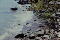
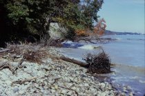
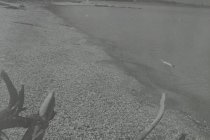
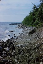
Concrete debris at Curren Beach - view looking south from Curren beach at south end of Bluff Road properties showing concrete debris at Curren beach, new reinforcement on lakeside of Dalitsch steel revetmentd
Concrete debris at Curren Beach
Record Type: Photo
-
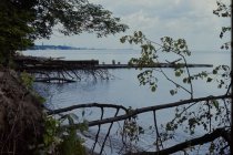
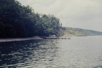
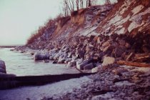
Erosion at Bluff Road bluffs - view looking north northwest from end of long concrete pier showing short concrete pier and adjacent steel groin, also shows very eroded Bluff Road bluffs, debris at base of Dalitsch property, partially eroded Crab Tree Farm bluff in distance with steel groins at Crab Tree Farm
Erosion at Bluff Road bluffs
Record Type: Photo
-
Erosion at Bluff Road Bluffs - view northwest from end of 1939 concrete pier (telephoto view) showing 1939 short concrete pier with adjacent steel groin, rubble at base of Dalitsch property, and eroded Bluff Road bluffs with armor stone and concrete debris at base of bluffs
Erosion at Bluff Road bluffs
Record Type: Photo
-
Fallen trees at Mountain Bluff - view looking north northeast from shore south of short concrete pier - shows treefall along base of Mountain Bluff and short steel groin adjacent to concrete pier
Fallen trees at Mountain Bluff
Record Type: Photo
-
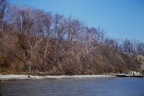
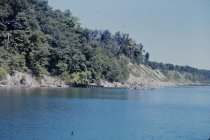
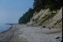
Looking up the Bluff Road bluffs - view looking south along Bluff Road bluffs - taken from north end of Bluff Road bluffs - eroded Bluff Road bluffs in foreground and lightly snow covered Dalitsch bluff in distance - note apparent concrete septic tank up bluff in foreground and erosion of Dalitsch bluff
Looking up the Bluff Road bluffs
Record Type: Photo
-
View north along the beach - view looking north along base of Mountain Avenue bluff taken from west end of concrete pier - shows start of erosion Mountain Avenue bluff - eroded narrow beach and in background is 1949 short steel groin installed immediately south of the 1939 short concrete pier
View north along the beach
Record Type: Photo
-
View north along the beach - view looking north along central and north beach taken from central beach - shows long concrete pier and wood retaining wall most likely at base of old beach roadway - top of short concrete pier can be seen just over top and beyond long concrete pier
View north along the beach
Record Type: Photo
-
View north along the beach - view looking north along Mountain Avenue bluff and north end of North Beach bluff taken from shore end of 1939 long concrete pier - close up view of erosion at base of bluff - 1939 short concrete pier with 1949 steel groin in distance
View north along the beach
Record Type: Photo
-
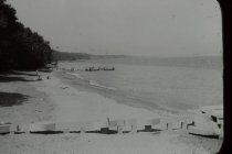
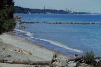
View north along the beach - view looking north along north beach and beyond from just south of long concrete pier - great view of shore end of pier - and shows short concrete pier in background - most likely early 1940's when lake level was lower -
View north along the beach
Record Type: Photo
-
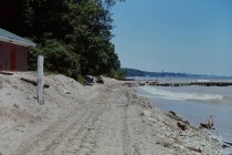
View north along the beach - view looking north along north end of central beach and north beach - shows beach being used as construction road for North Shore Sanitary District (NSSD) pump station - very narrow beach adjacent to the beach house - long concrete pier is shown and short steel groin next to short concrete pier in background
View north along the beach
Record Type: Photo
-
View north along the beach - view looking north from long 1939 concrete pier showing 1939 short concrete pier with 1949 steel groin, eroded Bluff Road bluffs, Crab Tree Farm bluffs, and Crab Tree Farm steel groins in distance
View north along the beach
Record Type: Photo
-
View north along the beach - view looking north from long concrete pier showing 1939 short concrete pier and adjacent 1949 steel groin, extensive rubble placed at toe of Bluff Road Bluffs, Bluff Road bluff erosion, and distant steel groins opposite south end of Crab Tree Farm, debris at Dalitsch property
View north along the beach
Record Type: Photo
-
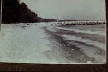
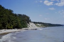
View north along the beach - view north along north beach and beyond from approximate location of west end of long concrete pier - shows accumulation of small natural rocks on beach and shows short concrete pier in background with slight buildup of beach north of concrete pier
View north along the beach
Record Type: Photo
-
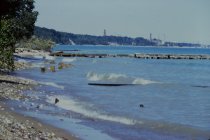
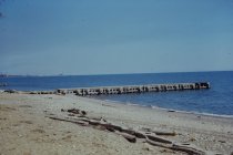
View north along the beach - view to north along beach from north end of North Shore Sanitary District (NSSD) parcel-shows short 1949 steel groin just at water level, long concrete pier and remnants of short concrete pier with short steel groin beyond - also shows concrete blocks at old beach road turn around area
View north along the beach
Record Type: Photo
-
View north along the beach - view to north along beach taken from central beach area - shows short steel groin built in 1949 about 100 feet south of beach house - shows concrete squares at perimeter of old beach road turn around area, and long concrete pier, and short old concrete pier just visible beyond
View north along the beach
Record Type: Photo
-
View northeast towards Dalitsch Bluff - view looking northwest taken from out on 1939 concrete pier - view shows extensive erosion of Bluff Road Bluffs and erosion of south end of Crab Tree Farm Bluffs - shows 1939 short concrete pier with 1949 steel groin- shows rubble on Dalitsch bluff and Angster house at the top of bluff
View northeast towards Dalitsch Bluff
Record Type: Photo
-
View north towards Dalitsch Bluff - view looking northwest taken from out on 1939 concrete pier - view shows extensive erosion of Buff Road bluffs and erosion of south end of Crab Tree Farm Bluffs - shows 1939 concrete short pier with 1949 short steel groin, rocks/debris at bottom of Dalitsch bluff
View north towards Dalitsch Bluff
Record Type: Photo
-
View northwest of Bluff Road bluffs - view north northwest from end of long 1939 concrete pier showing start of Mountain Avenue bluff failure, short concrete pier with adjacent steel groin, Dalitsch rubble behind steel groin, and then Bluff Road bluff erosion - steel groin in distance is at south end of Crab Tree Farm
View northwest of Bluff Road bluffs
Record Type: Photo
-
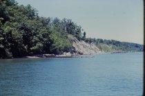
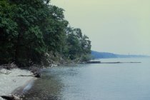
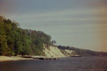
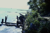
View of long concrete pier - view looking northeast towards 1939 long concrete pier taken from central beach - lake end of shorter 1939 concrete pier is in the background on the far left
View of long concrete pier
Record Type: Photo
-
View south along the beach - view looking south along beach from base of Bluff Road properties from Curren or Dahlman beach - shows Village's concrete storm sewer pipe at Lillian Dells and rubble dumping at Dalitsch property - also short and long 1939 concrete piers show in background
View south along the beach
Record Type: Photo
-
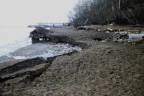
View south along the beach - view looking south along beach from just north of Lillian Dells Drive, view shows Village's concrete sewer outfall, 1939 short and long concrete piers and sheet pile revetment along Dalitsch property - end of winter season with ice / snow buildup still on still on beach
View south along the beach
Record Type: Photo
-
View south along the beach - view looking south along beach from north end of Bluff Road bluffs - shows severely eroded Bluff Road bluffs and concrete septic tank up on bluff - shows concrete debris in distance on beach (see slide #804 of this debris) - short and long 1939 concrete piers can be seen
View south along the beach
Record Type: Photo
-
View south along the beach - view looking south along beach taken from north end of Bluff Road bluffs - view of eroded bluffs and remaining concrete septic tank on bluff, rubble in distance on beach, shows long and short 1939 concrete piers
View south along the beach
Record Type: Photo
-
View south along the beach - view looking south along Bluff Road bluff from north end of Bluff Road bluff, view shows extensive rubble spread along toe of bluff - short 1939 concrete pier in distance, southerly steel groin of Crab Tree Farm in immediate foreground
View south along the beach
Record Type: Photo
-
View south along the beach - view looking south along toe of bluff from end of Lillian Dells drive showing closeup view of Dalitsch property steel revetment and supports - shows 1939 short and long concrete piers on background
View south along the beach
Record Type: Photo
-
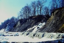
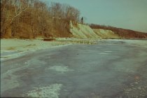
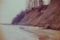
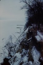
View south along the beach in winter - view looking south along beach and bluffs taken from north end of Bluff Road bluffs - shows very eroded Bluff Road bluffs - also shows 1939 short concrete pier, 1939 long concrete pier and North Shore Sanitary District (NSSD) outfall in distance
View south along the beach in winter
Record Type: Photo
-
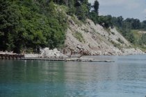
View west of bluffs - view looking northwest from 1939 long concrete pier looking at 1939 short concrete pier and adjacent 1949 steel groin - also shows debris fill on bluff at south end of Bluff Road (Angster property) and concrete debris at base of Dalitsch bluff
View west of bluffs
Record Type: Photo