Search Term Record
Metadata
Name |
Dalitsch |
Number of Archive records |
0 |
Number of Library records |
0 |
Number of Object records |
0 |
Number of Photo records |
15 |
Related Records
-
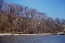
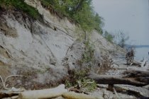
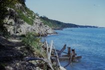
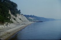
Erosion at Bluff Road bluffs - view looking north northwest from end of long concrete pier showing short concrete pier and adjacent steel groin, also shows very eroded Bluff Road bluffs, debris at base of Dalitsch property, partially eroded Crab Tree Farm bluff in distance with steel groins at Crab Tree Farm
Erosion at Bluff Road bluffs
Record Type: Photo
-
Erosion at Bluff Road Bluffs - view northwest from end of 1939 concrete pier (telephoto view) showing 1939 short concrete pier with adjacent steel groin, rubble at base of Dalitsch property, and eroded Bluff Road bluffs with armor stone and concrete debris at base of bluffs
Erosion at Bluff Road bluffs
Record Type: Photo
-
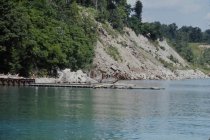
Erosion at Crab Tree Farm bluffs - view looking north from 1939 short concrete pier showing extensive erosion of Bluff Road bluffs, large rubble revetment along base of Bluff Road Bluff, steel groin at south end of Crab Tree Farm, rubble along base of Dalitsch bluff and Dalitsch steel revetment in left foreground
Erosion at Crab Tree Farm bluffs
Record Type: Photo
-
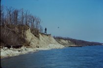
Erosion at Mountain Bluffs - view looking north bluff from just north of long concrete pier - shows extensive erosion of Mountain Bluffs - steel groin at location of short concrete pier in background - shows dumping of concrete debris down bluff at Dalitsch property, far north end of Park District property
Erosion at Mountain Bluffs
Record Type: Photo
-
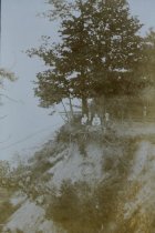
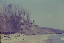
Erosion possibly Dalitsch Bluff - Location not certain but could be a view looking south along the lakefront from south end of Stearns' property (view across Lillian Dells) - shows very eroded bluff - exact time period not known
Erosion possibly Dalitsch Bluff
Record Type: Photo
-
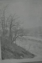
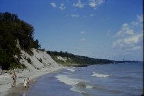
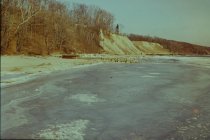
View north along the beach - Historic view along the lakefront - location is not known nor direction of view - could be a view across Lillian Dells Drive or could be a view across the Ravine Park Ravine - formerly known as the South Ravine - no known time period
View north along the beach
Record Type: Photo
-
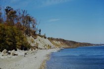
View north along the beach - view looking north along beach from approximately 1939 short concrete pier - shows concrete debris along base of Dalitsch bluff with concrete bracing of Dalitsch steel revetment just beyond - eroded Bluff Road bluff in center and Crab Tree Farm bluffs beyond - southerly Crab Tree Farm groin shown beyond
View north along the beach
Record Type: Photo
-
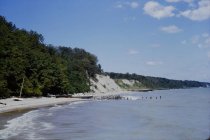
View north along the beach - view looking north along beach from Dalitsch parcel showing huge debris pile on south end of Bluff Road bluff, Dalitsch steel revetment in foreground with support structures, and Crab Tree Farm steel groins in background
View north along the beach
Record Type: Photo
-
View north along the beach - view looking north along beach taken from approximately 1939 short concrete pier - shows concrete bracing for Dalitsch steel revetment on left foreground - eroded Bluff Road bluffs in center and eroded Crab Tree Farm bluffs in background - southerly Crab Tree steel groin in background
View north along the beach
Record Type: Photo
-
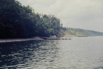
View north along the beach - view looking north from long 1939 concrete pier showing 1939 short concrete pier with 1949 steel groin, eroded Bluff Road bluffs, Crab Tree Farm bluffs, and Crab Tree Farm steel groins in distance
View north along the beach
Record Type: Photo
-
View north along the beach - view looking north from long concrete pier showing 1939 short concrete pier and adjacent 1949 steel groin, extensive rubble placed at toe of Bluff Road Bluffs, Bluff Road bluff erosion, and distant steel groins opposite south end of Crab Tree Farm, debris at Dalitsch property
View north along the beach
Record Type: Photo
-
View north along the beach - view looking north from west end of 1939 short concrete pier showing Dalitsch revetment in foreground, eroded Bluff Road bluffs, Crab Tree Farm bluff, and steel groins at south end of Crab Tree Farm - nearest groin in photo is at south end of Crab Tree Farm
View north along the beach
Record Type: Photo
-
View north along the beach - view looking north taken from approximately 1939 short concrete pier - Dalitsch bluff in foreground with sheet piling and concrete bracing - eroded Bluff Road bluffs in center and Crab Tree Farm bluffs in background - southerly groin of Crab Tree Farm aligned with East Blodgett Road at north
View north along the beach
Record Type: Photo
-
View northeast towards Dalitsch Bluff - view looking northwest taken from out on 1939 concrete pier - view shows extensive erosion of Bluff Road Bluffs and erosion of south end of Crab Tree Farm Bluffs - shows 1939 short concrete pier with 1949 steel groin- shows rubble on Dalitsch bluff and Angster house at the top of bluff
View northeast towards Dalitsch Bluff
Record Type: Photo
-
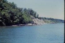
View west of bluffs - view looking northwest from 1939 long concrete pier looking at 1939 short concrete pier and adjacent 1949 steel groin - also shows debris fill on bluff at south end of Bluff Road (Angster property) and concrete debris at base of Dalitsch bluff
View west of bluffs
Record Type: Photo