Search Term Record
Metadata
Name |
Bluff Road bluff |
Number of Archive records |
0 |
Number of Library records |
0 |
Number of Object records |
0 |
Number of Photo records |
77 |
Related Records
-
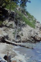
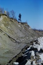
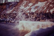
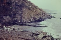
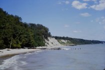
Beginning of slide at Mountain Bluffs - view northwest from 1939 long concrete pier showing start of Mountain Road bluff failure, 1949 short steel groin which is adjacent to short 1939 concrete pier(not shown) - in far right is debris on slope at south end of Bluff Road property
Beginning of slide at Mountain Bluffs
Record Type: Photo
-
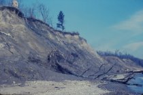
Debris along the beach - view looking north along beach from immediately south of Lillian Dells Drive showing south end of Bluff Road bluffs with extensive debris on bluff - Village's storm sewer outfall pipe at end of Lillian Dells Drive is in the left foreground
Debris along the beach
Record Type: Photo
-
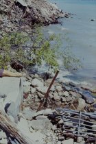
Debris at Curren Beach - view looking north along toe of bluff from just south of Village's concrete sewer outfall pipe - closeup view of extensive debris at base of Curren bluff at south end of Bluff road properties
Debris at Curren Beach
Record Type: Photo
-
Debris on Bluff Road bluff - view looking north along beach from end of Lillian Dells Drive showing extensive debris on south end of Bluff Road bluff - closeup view
Debris on Bluff Road bluff
Record Type: Photo
-
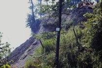
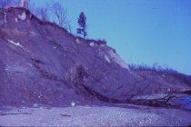
Erosion at Bluff Road bluff - view looking north along beach from end of Lillian Dells Drive showing debris on Bluff Road Bluff and continuing erosion, Crab Tree Farm steel groins in background
Erosion on Bluff Road bluff
Record Type: Photo
-
Erosion at Bluff Road bluffs - view looking north northwest from end of long concrete pier showing short concrete pier and adjacent steel groin, also shows very eroded Bluff Road bluffs, debris at base of Dalitsch property, partially eroded Crab Tree Farm bluff in distance with steel groins at Crab Tree Farm
Erosion at Bluff Road bluffs
Record Type: Photo
-
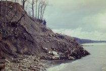
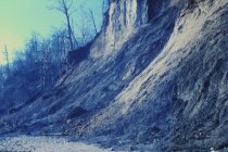
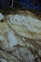
Erosion at Bluff Road bluffs - view looking northwest taken from just north of Lillian Dells Drive showing extreme erosion of Bluff Road bluffs - picture shows Stearns' Chimney back from bluff also shows apparent septic tank between Dahlman and Curren parcels
Erosion at Bluff Road bluffs
Record Type: Photo
-
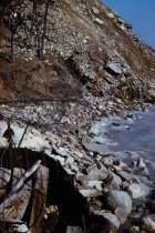
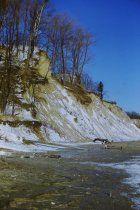
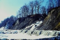
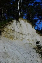
Erosion at Bluff Road bluffs - view looking northwest up Bluff Road bluff taken from beach at end of Lillian Dells Drive - shows extensive bluff erosion under light snow cover
Erosion at Bluff Road bluffs
Record Type: Photo
-
Erosion at Bluff Road bluffs - view looking south along south end of Bluff Road bluff - view shows crumbling concrete septic tank on bluff in far right Early 1966
Erosion at Bluff Road bluffs
Record Type: Photo
-
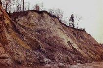
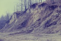
Erosion at Bluff Road bluffs - view looking southwest from base of Bluff Road Bluffs - close up view looking up the south end of the Bluff Road bluff - severe erosion Late 1965 early 1966
Erosion at Bluff Road bluffs
Record Type: Photo
-
Erosion at Bluff Road Bluffs - view northwest from end of 1939 concrete pier (telephoto view) showing 1939 short concrete pier with adjacent steel groin, rubble at base of Dalitsch property, and eroded Bluff Road bluffs with armor stone and concrete debris at base of bluffs
Erosion at Bluff Road bluffs
Record Type: Photo
-
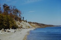
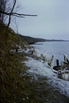
Erosion at Crabtree Farm bluffs - view looking north along beach from Lillian Dells Drive, showing eroded Bluff Road bluffs and eroded Crab Tree Farm bluffs in the distance - end of winter scene showing ice and snow buildup on beach, southerly Crab Tree Farm steel groin in distance
Erosion at Crabtree Farm bluffs
Record Type: Photo
-
Erosion at Crabtree Farm bluffs - view looking north along beach from Lillian Dells showing erosion of Bluff Road property bluffs - eroded Crab Tree Farm bluffs in the distance, and rock revetment at base of bluffs
Erosion at Crabtree Farm bluffs
Record Type: Photo
-
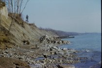
Erosion possibly Dalitsch Bluff - Location not certain but could be a view looking south along the lakefront from south end of Stearns' property (view across Lillian Dells) - shows very eroded bluff - exact time period not known
Erosion possibly Dalitsch Bluff
Record Type: Photo
-
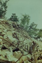
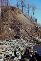
Extensive debris on Bluff Road bluff - view looking northeast from lake end of Lillian Dells Drive looking up south end of Bluff Road bluff face showing closeup view of the extensive debris dumped on the bluff face Late 1960s or early 1970s
Extensive debris on Bluff Road bluff
Record Type: Photo
-
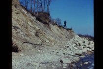
Looking at Dalitsch Bluff from top of Bluff Road bluffs - view looking southwesterly up bluff at south end of Bluff Road Bluff - view shows equipment at top of bluff reported to be working on Curren property lawn
Looking at Dalitsch Bluff from top of Bluff Road bluff
Record Type: Photo
-
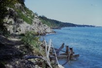
Looking down Bluff Road bluff - view looking down from top of Bluff Road bluff at concrete debris on beach (see slide #805 of this debris looking along beach from the north)
Looking down Bluff Road bluff
Record Type: Photo
-
Looking down the Bluff Road bluffs - view looking easterly down bluff taken from north end of Hall property (north end of Bluff Road properties and just south of south end of Crab Tree Farm parcels - shows newly dumped concrete debris on bluff - steel groin is the southerly groin on the Crab Tree Farm parcel
Looking down the Bluff Road bluffs
Record Type: Photo
-
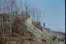
Looking up the Bluff Road bluff - view looking nearly straight up Bluff Road bluff at Stearns' Chimney - closeup shot
Looking up the Bluff Road bluff
Record Type: Photo
-
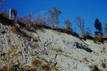
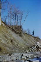
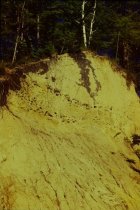
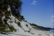
Looking up the Bluff Road bluffs - view looking northwest along Bluff Road bluffs taken from south end of Bluff Road bluffs looking at eroded bluffs and initial work to build the rock revetment at the base of the bluffs - Stearns' Chimney shown
Looking up the Bluff Road bluffs
Record Type: Photo
-
Looking up the Bluff Road bluffs - view looking north west at Bluff Road bluffs taken from beach opposite Lillian Dells Drive outlet - view shows eroded bluff, Stearns' Chimney and material for rock revetment to be constructed stockpiled on beach
Looking up the Bluff Road bluffs
Record Type: Photo
-
Looking up the Bluff Road bluffs - view looking northwest up Bluff Road bluffs from end of Lillian Dells Drive - shows erosion of bluffs, Stearns' Chimney at top and rock piled at toe of bluffs in preparation for construction of rock revetment along base of Bluff Road bluffs
Looking up the Bluff Road bluffs
Record Type: Photo
-
Looking up the Bluff Road bluffs - view looking northwest up Bluff Road Bluffs taken from beach near south end of Bluff Road bluffs - Shows Stearns Chimney and initial work to build the rock revetment at the base of the bluffs
Looking up the Bluff Road bluffs
Record Type: Photo
-
Looking up the Bluff Road bluffs - view looking northwest up Bluff Road bluff taken from beach at end of Lillian Dells Drive - shows eroded Bluff Road bluffs with Stearns' Chimney and chain link fence on top of bluff at south end of Crab Tree Farm - steel groin is at south end of Crab Tree Farm opposite East Blodgett Avenue
Looking up the Bluff Road bluffs
Record Type: Photo
-
Looking up the Bluff Road bluffs - view looking northwest up Bluff Road bluff taken from beach at end of Lillian Dells Drive - shows eroded Bluff Road bluffs with Stearns' Chimney and chain link fence on top of bluff at south end of Crab Tree Farm - steel groin is at south end of Crab Tree opposite East Blodgett Avenue
Looking up the Bluff Road bluffs
Record Type: Photo
-
Looking up the Bluff Road bluffs - view looking south along Bluff Road bluffs - taken from north end of Bluff Road bluffs - eroded Bluff Road bluffs in foreground and lightly snow covered Dalitsch bluff in distance - note apparent concrete septic tank up bluff in foreground and erosion of Dalitsch bluff
Looking up the Bluff Road bluffs
Record Type: Photo
-
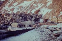
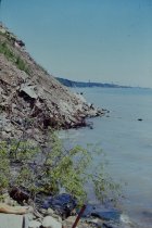
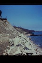
Rubble at base of Bluff Road bluffs - view looking southwesterly at north end of Bluff Road bluff taken from just north of southerly Crab Tree Farm steel groin - shown in right foreground is the southerly end of short rock / wall gabion baskets constructed along southerly portion of Crab Tree Farm bluff
Rubble at base of Bluff Road bluffs
Record Type: Photo
-
Rubble at base of Bluff Road bluffs - view looking southwesterly at north end of Bluff Road bluff taken from most southerly steel groin of Crab Tree Farm - view shows ruble and rocks spread along toe of north end of Bluff Road bluff
Rubble at base of Bluff Road bluffs
Record Type: Photo
-
Rubble at Bluff Road bluff - view looking north along beach from end of Lillian Dells Drive showing debris on south end of Bluff Road Bluff, extensive debris around Village's concrete outfall pipe at Lillia Dells Drive
Rubble at Bluff Road bluff
Record Type: Photo
-
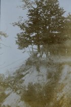
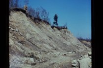
Swallows' nests in Bluff Road bluff - view looking west north west up the face of the south end of the Angster bluff, south end of Bluff Road bluff, showing swallows' nests in bluff face
Swallows' nests in Bluff Road bluff
Record Type: Photo
-
Swallows' nests in Bluff Road bluff - view looking west north west up the face of the south end of the Angster bluff, south end of Bluff Road bluff, showing swallows' nests in bluff face Mid 1964
Swallows' nests in Bluff Road bluff
Record Type: Photo
-
Swallows' nests in Bluff Road bluff - view looking west north west up the face of the south end of the Angster bluff, south end of Bluff Road bluff, showing swallows' nests in bluff face Mid 1964
Swallows' nests in Bluff Road bluff
Record Type: Photo
-
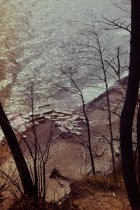
View north along the beach - view looking north along beach from approximately 1939 short concrete pier - shows concrete debris along base of Dalitsch bluff with concrete bracing of Dalitsch steel revetment just beyond - eroded Bluff Road bluff in center and Crab Tree Farm bluffs beyond - southerly Crab Tree Farm groin shown beyond
View north along the beach
Record Type: Photo
-
View north along the beach - view looking north along beach from Dalitsch parcel showing huge debris pile on south end of Bluff Road bluff, Dalitsch steel revetment in foreground with support structures, and Crab Tree Farm steel groins in background
View north along the beach
Record Type: Photo
-
View north along the beach - view looking north along beach from immediately south of Lillian Dells Drive showing south end of Bluff Road bluffs with extensive debris on bluff
View north along the beach
Record Type: Photo
-
View north along the beach - view looking north along beach from immediately south of Lillian Dells Drive showing south end of Bluff Road bluffs with extensive debris on Bluff Road bluff, Crab Tree Farm steel groins in background and concrete debris at northeast corner of Dalitsch property in the foreground
View north along the beach
Record Type: Photo
-
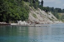
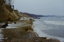
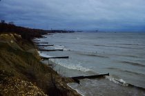
View north along the beach - view looking north along beach opposite Bluff Road bluff - shows beach area along Bluff Road Bluff in foreground one year after rock revetment constructed at toe of bluffs - Crab Tree Farm groins in background
View north along the beach
Record Type: Photo
-
View north along the beach - view looking north along beach taken from approximately 1939 short concrete pier - shows concrete bracing for Dalitsch steel revetment on left foreground - eroded Bluff Road bluffs in center and eroded Crab Tree Farm bluffs in background - southerly Crab Tree steel groin in background
View north along the beach
Record Type: Photo
-
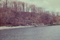
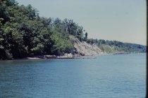
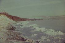
View north along the beach - view looking north along beach taken from approximately north end of Bluff Road properties looking at Crab Tree Farm bluffs, - winter scene with bluffs covered with snow
View north along the beach
Record Type: Photo
-
View north along the beach - view looking north along beach taken from Lillian Dells Drive - shows eroded Bluff Road bluffs and Crab Tree Farm bluffs in distance - steel groin shown is the southerly most groin at Crab Tree Farm aligned with E. Blodgett Avenue extended
View north along the beach
Record Type: Photo
-
View north along the beach - view looking north along beach taken from middle of Bluff Road bluffs, showing eroded Bluff Road bluffs and shows rock revetment work underway - nearest steel groin shown is at the south end of Crab Tree Farm opposite East Blodgett Avenue, eroded Crab Tree Farm bluffs in background
View north along the beach
Record Type: Photo
-
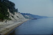
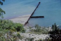
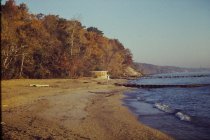
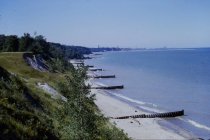
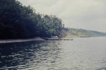
View north along the beach - view looking north along central beach taken from north edge of North Shore Sanitary District (NSSD) parcel showing long concrete pier, beach house, and short 1949 steel groin in middle of central beach, and denuded Bluff Road bluffs in distance
View north along the beach
Record Type: Photo
-
View north along the beach - view looking north along Southerly end of Crab Tree Farm lakefront - photo taken from top of Bluff from middle of Bluff Road properties - photo shows eroded Crab Tree Farm bluff and steel groin field installed along south end of Crab Tree Farm - southerly groins aligns with East Blodgett Avenue
View north along the beach
Record Type: Photo
-
View north along the beach - view looking north along Southerly end of Crab Tree Farm lakefront - photo taken from top of Bluff from middle of Bluff Road properties - photo shows eroded Crab Tree Farm bluff and steel groin field installed along south end of Crab Tree Farm -southerly groins aligns with East Blodgett Avenue
View north along the beach
Record Type: Photo

-
View north along the beach - view looking north along toe of bluff below the Dalitsch property - shows extensive concrete debris below Angster property - in right foreground is the steel revetment and bracing of the revetment for the Dalitsch property
View north along the beach
Record Type: Photo
-
View north along the beach - view looking north from beach opposite the end of Lillian Dells Drive - view shows eroded Bluff Road bluffs in foreground and Crab Tree Farm bluffs in distance - pile of revetment stones on beach and also concrete debris on beach and in water - steel groin is at south end of Crab Tree Farm
View north along the beach
Record Type: Photo
-
View north along the beach - view looking north from long 1939 concrete pier showing 1939 short concrete pier with 1949 steel groin, eroded Bluff Road bluffs, Crab Tree Farm bluffs, and Crab Tree Farm steel groins in distance
View north along the beach
Record Type: Photo
-
View north along the beach - view looking north from long concrete pier showing 1939 short concrete pier and adjacent 1949 steel groin, extensive rubble placed at toe of Bluff Road Bluffs, Bluff Road bluff erosion, and distant steel groins opposite south end of Crab Tree Farm, debris at Dalitsch property
View north along the beach
Record Type: Photo
-
View north along the beach - view looking north from west end of 1939 short concrete pier showing Dalitsch revetment in foreground, eroded Bluff Road bluffs, Crab Tree Farm bluff, and steel groins at south end of Crab Tree Farm - nearest groin in photo is at south end of Crab Tree Farm
View north along the beach
Record Type: Photo