
Archive Record
Images
Metadata
Title |
The Lake Bluff Zoning Map |
Description |
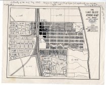
The Lake Bluff Zoning Map December 1923 corrected to February 1931 and marked up in August 1937 Similar to Map 76, this map shows intensity of use as of August 1937. Figure on the left is number of houses and apartments now existing. Figure on the right is total number of houses and apartments that may exists under zoning ordinance. Density usage |
Caption |
Lake Bluff Zoning Map |
Date |
1923 |
Search Terms |
Zoning Map Density usage |
Collection |
Maps |
Object Name |
Map |
Object ID |
Map 77 |